
Reading the signs, clouds, wave trains and the barometer
By Dick Beaumont
Satellites have replaced seaweed when it comes to weather forecasting, but what happens when you cannot connect for whatever reason? We know we cannot rely 100% on the availability of that satellite streamed information being accessible whenever we need it. Power supply issues, computer glitches, or supply side failures can and do happen.
For the same reasons that a skipper should carry hard copy charts and a sextant, rather than be totally reliant on the plotter and GPS, he should also carry a barometer, a hygrometer and train himself to read the natural signs, from sea and sky.
Using the wind to cross an ocean develops a symbiosis between the sailor and the elements, as the dependency on wind and wave becomes apparent. Being at one with the environment is one of the greatest satisfactions a sailor experiences.
There are many signposts from the sea and sky that give us clues about the weather to come, if only we know what to look for.
Wave Patterns
Most people think the first visual sign of a change in the weather comes from clouds, but wave patterns often provide an earlier signal.
The same way surfers use swells that are produced hundreds of miles from the beach they break upon, experienced mariners will look for an underlying wave or swell pattern that has been generated by a weather system many miles from the one which is impacting on them directly.
Look for an underlying swell, not a wave, this will tell you of the disturbance a weather system has kicked up in another part of the ocean or sea you are sailing in (see Fig.1).
The ancient Polynesians read the sea and it’s moods, using wave patterns to navigate to distant islands as well as to understand the position of weather systems. That might seem fantastic to modern sailors but Fig.2 below explains how they did it.


Clouds
More can be learned from the progression of the changing cloud formations than just the observation of the clouds types themselves.
This illustration shows where in the atmosphere the various cloud formations will be.
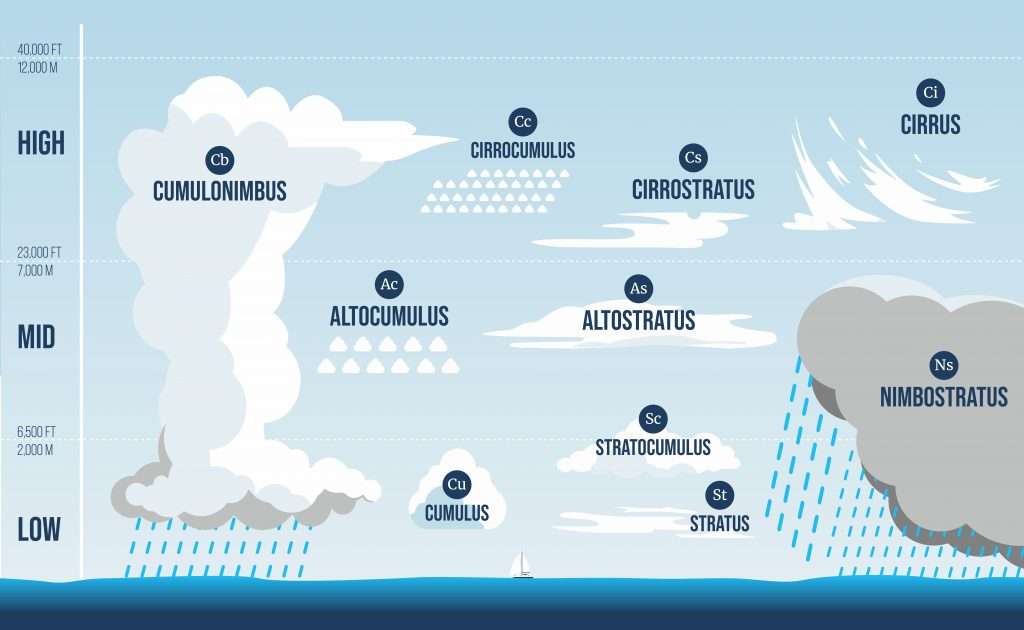
Ci Cirrus

The first sign that bad weather may be approaching is the appearance of cirrus clouds in the upper atmosphere.
These clouds are formed by ice crystals and their streaky look is caused by high wind in the upper atmosphere. They are commonly known as ‘Mares’ Tails’, as in the tail of a horse.
Typically, the weather will deteriorate the following day, perhaps sooner, as the warm front of the depression approaches.
You can’t be certain that bad weather is coming unless you’ve built up an understanding of the weather over the last week or so because the cirrus you are looking at may be the residue of a depression which has already passed.

Cc Cirrocumlus

These high altitude clouds are quite rare in that they may only be quite short lived. They are often seen with, or layering underneath, cirrus clouds.
They are often referred to as a Mackerel Sky, which sailors of old said should never be trusted.

Cs Cirrostratus

These clouds will be seen around 12 hours before a depression arrives. They are a thin veil covering the whole sky, producing a halo around a bright moon. The tighter the halo’s circle is around the moon, the closer the approaching depression/storm is.
Cirrus clouds alone do not always herald bad weather, but the combination of cirrus followed by cirrostratus is a sure sign of bad weather coming. You can expect the warm front, which is associated with a low-pressure system accompanied by rain, to arrive first in six to eight hours, depending on how big the depression/storm is and how far to one side or other you are of it’s leading edge.

As Altostratus

Lower and thicker than cirrostratus, altostratus is, when seen in sequence following cirrus and cirrostratus, further confirmation a depression is heading your way. You may see a dimmed sun through these clouds but they will thicken further to obscure it in a flat blanket of grey cloud.
At the onset of these clouds you can reckon the warm front, with rain and increased wind, is close approaching you, and will arrive in the next four or five hours. Keep your eyes on the horizon from where the wind is coming, to witness its arrival.

Ns Nimbostratus

By now you know you are in it! As the warm front clouds of nimbostratus (Fig.1) start producing heavy rain, running clouds of ragged fractostratus, scudding clouds, will also appear dark and threatening ahead of the front, as it goes through.

CB Cumulonimbus

While you are in the warm sector, although visibility may be poor due to the higher humidity, look out for the taller and higher cumulonimbus clouds. You may be able to see them in the distance as the cold front advances (Fig.3).
The cold front is often the most violent part of the weather system. Winds may veer and increase considerably as the front hits, then back again once you are in the cold sector.
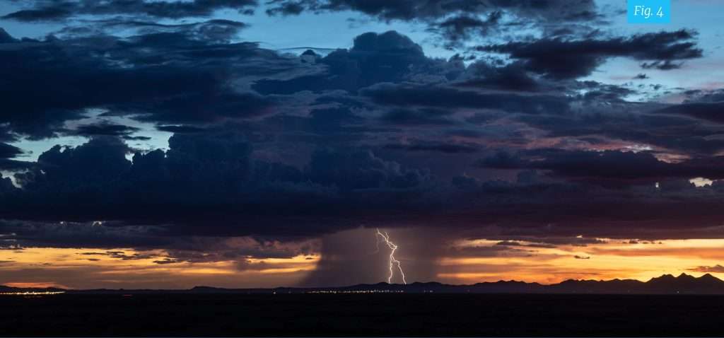
Cumulonimbus are also the clouds associated with thunderstorms, which may, or may not, be part of a bigger weather system. You need to be aware of their proximity to you and the direction they are travelling in (Fig.4W).
They are caused when warm moist air starts to ascend quickly into the higher, colder atmosphere. The rising air leaves a partial vacuum beneath it and ambient air rushes in to fill it, creating sudden strong winds which will veer and then back as the thunderstorm passes through.
They are towering anvil-headed clouds that look very menacing, and they often are.
It’s common for a nice gentle warm breeze of 10kts to turn into a devastating maelstrom of a white squall in less than 5 minutes with winds of 40kts and horizontal stinging rain for 30mins, before it is gone again and back to calm seas, but leaving a trail of destruction behind it.

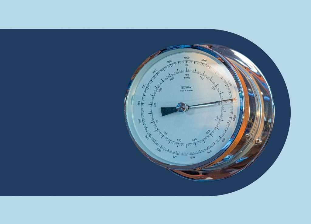
Barometers
It is increasingly rare to find a barometer onboard a yacht, let alone see someone using it. It’s vital that you have one, learn how to use it and record the reading hourly in the ship’s log. A drop of 1 millibar over an hour is telling you a low-pressure system is coming or that you are sailing towards it.
Once the barometer starts dropping more than 2 millibars an hour, batten down the hatches and prepare for a blow. A fall of over 3 millibars an hour will mean you’re in for a storm.
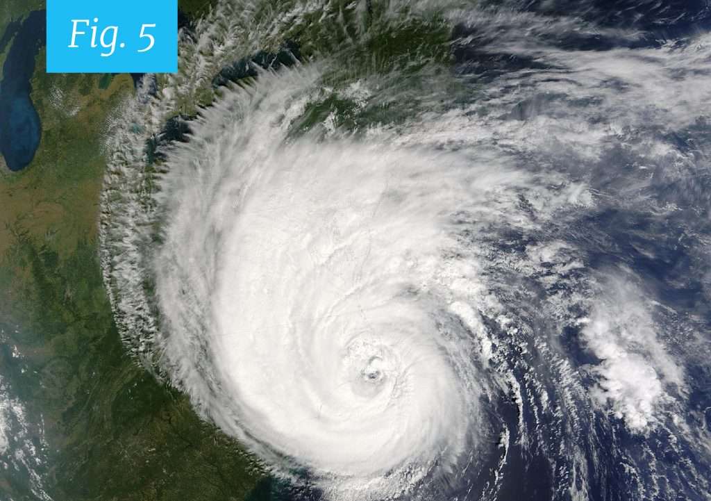
What you won’t know, without seeing a weather chart, is how deep that depression is. They range from around 1,000 millibars for an average minor depression, to a category 5 cyclone (hurricanes or typhoons are the same thing) with a pressure of less than 920 millibars. Hurricane Wilma was the lowest ever recorded, at 882 millibars. The deeper the depression the greater the wind (See Fig. 5).
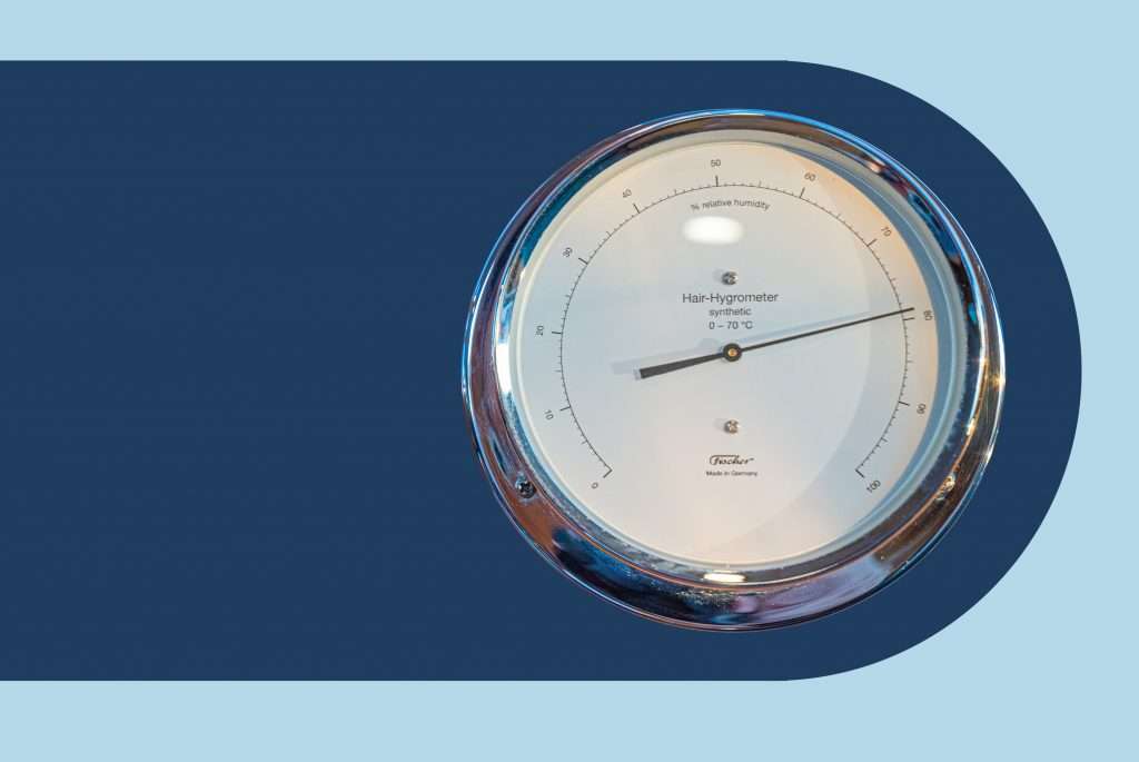
Hygrometers
This is a very useful instrument used for measuring humidity. It will allow you to determine whether you are now in the warm sector or cold sector of a depression or, for example, whether fog is likely to start forming according to whether the air and sea temperatures are becoming similar as well.
Now where is it?
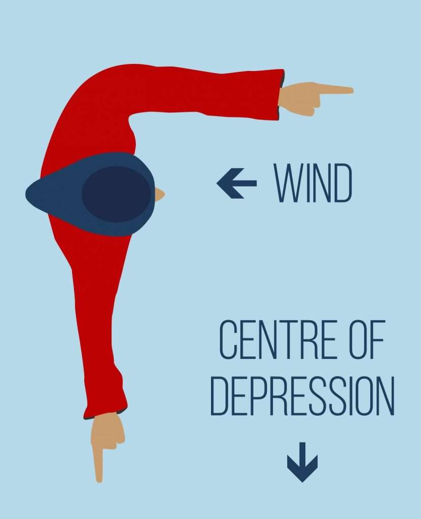
Our satellite communications are still down, we’ve watched the clouds, looked at the wave patterns, checked the barometer and the hygrometer and we know there’s a storm coming, but where, in relation to our position and our intended course, is it? Face directly into the wind, not the apparent wind, and if you’re in the northern hemisphere hold your right arm out from your side (left arm if you’re in the southern hemisphere) and your right hand is pointing to the centre of the depression, give or take 10 degrees. As shown below.
You can’t know how far you are from the centre, but you can determine which direction you need to sail to move away from the storm. In the Northern hemisphere, going ahead directly against the wind will maintain your distance from the storm’s epicentre, but bashing dead upwind isn’t fun at all. Turning to starboard will take you towards the centre, so a tack to port is the sensible course to take.
Many years ago I did have the misfortune to be caught in a severe storm while sailing from Palawan in the Philippines to Borneo when an un-forecast typhoon formed (I didn’t have sat comms back then). We had battled very heavy weather for 12 hours when my friend and crew Mark called down to me at the nav desk saying “it looks like it is over at last, the sky is blue, the wind has dropped and the clouds have gone, Hallelujah!”. I came out into the cockpit, looked up and saw a perfectly circular big blue hole in the clouds.
We were right in the eye of the storm! It was calm for an hour, then we got bashed for another eight hours as we sailed out the other side.
If I had known then what I know now!