

Readers’ favourite Anchorages of the World. Showcasing your favourite anchorages.
Cuttyhunk
From John, Ocean Sailor reader from the United States
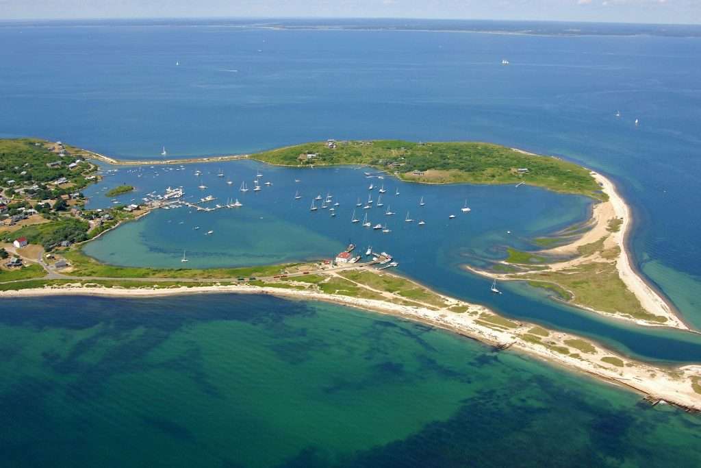
Location: Cuttyhunk, Elizabeth Islands, Massachusetts, USA
Coordinates: 41°25.53’N 70°55.60’W
Seabed: Mix of mud and sand in 3-5 meters of water
Protection: Weather favourable anchorage from prevailing west and southwest winds
The sailing around the New England coastline offers a great experience to cruisers. South of the Cape Cod Canal at the very tip of the Elizabeth Islands is Cuttyhunk Harbor. Cuttyhunk is the only inhabited island in the Elizabeth Islands chain with only 10 year-round residents. In the summer months, this number increases, as it is a popular place of outstanding natural beauty to escape to. Any easy day’s sail from busy Martha’s Vineyard or Newport, Cuttyhunk is a quiet world apart. In season, there is a small food shack on the dock that sells fresh caught tasty seafood.
A dredged channel allows access to the harbour. Only moorings are available in the harbour and if you don’t want to pay for a mooring in the fully protected harbour, people anchor just outside when the weather is favourable.


Arap Adası
From Ümit Özkan,Ocean Sailor reader from Turkey

Location: Arap Adası, Muğla, Turkey
Coordinates: 36°39.101’N 28°8.69’E
Seabed: Good holding in sand
Protection: Well protected apart from southerly winds
There is no shortage of excellent safe anchorages down the Turkish coast but Arap Adası is my favourite. Located between Bozukkale and Marmaris, this small island surrounded by turquoise blue water has a max depth of 16 meters and provides a great shelter from the meltemi wind and swell.
I generally anchor facing the mainland with long lines to the island to get the evening breeze over the bow. The crystal clear water is cooled down with fresh water entering the bay making it a great swim on the hot summer days. The beautiful bay is protected by an island with 2 entrances (north and south) and the average depth is about 12 meters.
It is believed that it was used as a stop from boats coming from Rhodes to the south. A few columns have been spotted underwater. This combined with the excellent visibility makes it a good place to don your diving gear and explore.
It is commonly used as a day stop for tourist boats and sailing yachts, but rarely used in the evening since it doesn’t have a restaurant. There is also a very pretty beach but you might have to share it with some local goats.


Disappointment Cove
From Dick Beaumont, Chairman and Founder of Kraken Yachts
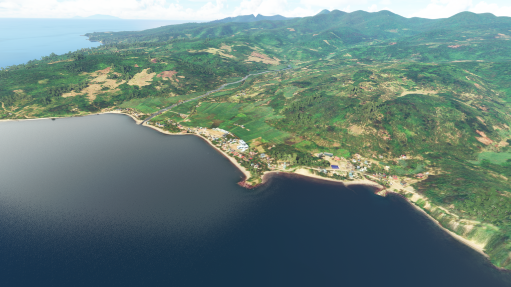
Location: Mambit Cove, Camiguin Island, Batanes Islands, North Philippines
Coordinates: 18°54.34’N 121°51.66’E
Seabed: Fine sand, good holding
Protection: Protected completely from the prevailing southeast winds and even if the winds swung from the west or north full shelter was available behind Pamoctan Island.
This Anchorage was the last stop on a 13,000nm voyage from New Zealand to Hong Kong.
In searching for a good last stop on our last leg from Palau, I had found this perfect looking bay. It was at the right distance to arrive there late evening, intending to depart the following morning, but as I zoomed in I saw 4 wreck icons marked on the chart. As readers may know diving, especially wreck diving, is another passion of mine.
After some intense online research, to my amazement, it seemed the 4 wrecks were those of four battleships of the Imperial Japanese fleet sunk there in WWII. All the wrecks were at a diveable depth and my crew and I became very excited at the prospect of diving these virtually unknown wrecks.
After obtaining permission to dive the wrecks from the village Barangay Captain (Head Man) we prepared to dive with great anticipation.
When we had arrived in the anchorage the previous afternoon there had been a local panga anchored over the wreck location, but now we had the dive site to ourselves.
We were so excited at the prospect of diving the potentially un-dived wreck we drew straws for who would go first. I was first down, but as I dropped down through the clear waters of the bay I couldn’t quite work out what I was seeing, as all that I could see that was left of the huge battleship was a 100ft long prop shaft tube and 10’-12 feet of curving steel hull maybe 50 feet long! The area around the site was littered with 8”x 3”x1” steel bars along with dozens of broken hacksaw blades?!?
The Barangay Captain told us they had been cutting up the battleship using Hookah gear and hand hacksaws for 25 years for scrap metal!
Many of the divers had been crippled by decompression sickness (the bends) and they had eradicated what would have undoubtedly been one of the world’s greatest dive sites and tourist resources for a few pesos of scrap steel and brass.
There was nothing left at all of the other three smaller wrecks which were in shallower water.

